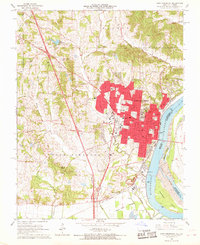
1967 Map of Cape Girardeau
USGS Topo · Published 1968About this map
The city of Cape Girardeau dominates this mid-century survey, positioned along the western bank of the Mississippi River as it passes Giboney Island. The urban core is a dense network of institutional and educational landmarks, including Southeast Missouri State College, St Vincents College, and Notre Dame High Sch. Extensive public spaces like Arena Park and Capaha Park provide greenery amidst the residential expansion pushing westward toward the Kings Highway.
Find a feature on this map
93 named features on this map. Tap any name to fly to it.
Don’t see what you’re looking for? This feature index may not catch every label — zoom into the map to look around manually.
Map Details
Editions of this 1967 Cape Girardeau Map
2 editions found
Other maps of this area

1920 · Jonesboro
USGS Topo · 1:62,500

1922 · Cape Girardeau
USGS Topo · 1:62,500

1923 · Jonesboro
USGS Topo · 1:62,500

1924 · Cape Girardeau
USGS Topo · 1:62,500

1934 · Thebes
USGS Topo · 1:62,500

1934 · Morley
USGS Topo · 1:62,500

1939 · Morley
USGS Topo · 1:62,500

1939 · Thebes
USGS Topo · 1:62,500

1947 · Jonesboro
USGS Topo · 1:62,500

1947 · Mc Clure
USGS Topo · 1:24,000