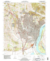
1993 Map of Cape Girardeau
USGS Topo · Published 1995About this map
The Mississippi River defines the eastern edge of this Missouri riverfront city, where the Burlington Northern railroad lines trace the bank and Southeast Missouri State University anchors the central urban landscape. The topography transitions from the alluvial Black Land Bottom in the south to the rolling hills of the north and west. Dozens of small cemeteries, including St Marys Cem, Old Hanover Cem, and the family-named Scism-Minton Cem, offer a rich record of the area's early settlement families and rural heritage outside the city center. Interstate development is visible at Interchange 96 and Interchange 93, illustrating the city's growth in the late twentieth century. To the west, Mount Tabor stands as a distinct landmark, while river features like Giboney Island and Marquette Island show the shifting character of the channel before the turn of the millennium.
Find a feature on this map
41 named features on this map. Tap any name to fly to it.
Don’t see what you’re looking for? This feature index may not catch every label — zoom into the map to look around manually.
Map Details
Editions of this 1993 Cape Girardeau Map
2 editions found
Other maps of this area

1920 · Jonesboro
USGS Topo · 1:62,500

1922 · Cape Girardeau
USGS Topo · 1:62,500

1923 · Jonesboro
USGS Topo · 1:62,500

1924 · Cape Girardeau
USGS Topo · 1:62,500

1934 · Thebes
USGS Topo · 1:62,500

1934 · Morley
USGS Topo · 1:62,500

1939 · Morley
USGS Topo · 1:62,500

1939 · Thebes
USGS Topo · 1:62,500

1947 · Jonesboro
USGS Topo · 1:62,500

1947 · Mc Clure
USGS Topo · 1:24,000