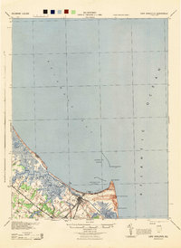
1944 Map of Cape Henlopen
USGS Topo · Published 1944About this map
Cape Henlopen stands at the critical junction where the Delaware Bay meets the Atlantic Ocean, a maritime landscape dominated by protective infrastructure and shifting sands. Compiled during the Second World War by the War Department and Corps of Engineers, U.S. Army, this map details the strategic shoreline of Sussex County. The town of Lewes serves as the inland hub, connected by the Pennsylvania railroad line, while the coast is marked by the Cape Henlopen Light, multiple Coast Guard Sta locations, and the defensive Breakwater Harbor.
Find a feature on this map
21 named features on this map. Tap any name to fly to it.
Don’t see what you’re looking for? This feature index may not catch every label — zoom into the map to look around manually.
Map Details
Editions of this 1944 Cape Henlopen Map
This is the sole edition of this map. No revisions or reprints were ever made.
Other maps of this area

1888 · Cape May
USGS Topo · 1:62,500

1888 · Dennisville
USGS Topo · 1:62,500

1890 · Maurice Cove
USGS Topo · 1:62,500

1891 · Maurice Cove
USGS Topo · 1:62,500

1893 · Cape May
USGS Topo · 1:62,500

1894 · Dennisville
USGS Topo · 1:62,500

1898 · Cape May
USGS Topo · 1:62,500

1899 · Vineland
USGS Topo · 1:125,000

1917 · Millsboro
USGS Topo · 1:62,500

1918 · Cedar Creek
USGS Topo · 1:62,500