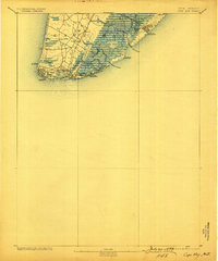
1893 Map of Cape May
USGS Topo · Published 1899About this map
The tip of the Jersey Shore appears as a complex landscape of tidal marshes and emerging resort communities in this late 19th-century survey. Cape May City and West Cape May anchor the southern peninsula, while the Atlantic coast shows early development at Holly Beach and Anglesea. This era is defined by the heavy presence of the Life-Saving Service, with stations placed at critical maritime points including L.S. Station Bay Shore and L.S. Station Turtle Gut. Transportation networks are dominated by specialized rail lines such as the Cape May and Sewells Point R.R. and the Delaware Bay and Cape May R.R., which connected the towns to the shore. The interior remains largely dominated by expansive wetlands like Jarvis Sound and Grassy Sound, separated from the ocean by barrier islands like Five Mile Beach and Two Mile Beach.
Find a feature on this map
35 named features on this map. Tap any name to fly to it.
Don’t see what you’re looking for? This feature index may not catch every label — zoom into the map to look around manually.
Map Details
Editions of this 1893 Cape May Map
4 editions found
Other maps of this area

1884 · Sea Isle
USGS Topo · 1:62,500

1888 · Cape May
USGS Topo · 1:62,500

1888 · Dennisville
USGS Topo · 1:62,500

1888 · Sea Isle
USGS Topo · 1:62,500

1890 · Maurice Cove
USGS Topo · 1:62,500

1891 · Maurice Cove
USGS Topo · 1:62,500

1893 · Cape May
USGS Topo · 1:62,500

1894 · Dennisville
USGS Topo · 1:62,500

1894 · Sea Isle
USGS Topo · 1:62,500

1898 · Cape May
USGS Topo · 1:62,500