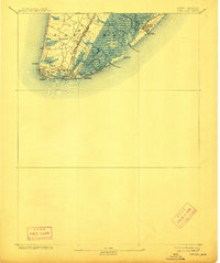
1893 Map of Cape May
USGS Topo · Published 1912About this map
The tip of the Cape May peninsula is defined by a dense network of late 19th-century rail infrastructure and coastal life saving stations. At this time, the southern Jersey Shore was a patchwork of developing resort towns and vital maritime markers. The West Jersey and Seashore R.R. and the Atlantic City R.R. provide clear evidence of the era's expanding tourism and transportation routes, terminating at Cape May City and Holly Beach.
Find a feature on this map
36 named features on this map. Tap any name to fly to it.
Don’t see what you’re looking for? This feature index may not catch every label — zoom into the map to look around manually.
Map Details
Editions of this 1893 Cape May Map
4 editions found
Other maps of this area

1884 · Sea Isle
USGS Topo · 1:62,500

1888 · Cape May
USGS Topo · 1:62,500

1888 · Dennisville
USGS Topo · 1:62,500

1888 · Sea Isle
USGS Topo · 1:62,500

1890 · Maurice Cove
USGS Topo · 1:62,500

1891 · Maurice Cove
USGS Topo · 1:62,500

1893 · Cape May
USGS Topo · 1:62,500

1894 · Dennisville
USGS Topo · 1:62,500

1894 · Sea Isle
USGS Topo · 1:62,500

1898 · Cape May
USGS Topo · 1:62,500