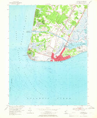
1954 Map of Cape May
USGS Topo · Published 1966About this map
Cape May Harbor and the surrounding coastline define this mid-century survey of New Jersey's southern tip. The landscape is a complex intersection of maritime navigation and terrestrial transport, featuring the Cape May Canal cutting across the peninsula to connect Delaware Bay with the Intracoastal Waterway. Military and civic infrastructure are prominent, including the U S Naval Res and the U S Coast Guard Receiving Center, alongside landmarks like the historic Lighthouse near Cape May Point.
Find a feature on this map
70 named features on this map. Tap any name to fly to it.
Don’t see what you’re looking for? This feature index may not catch every label — zoom into the map to look around manually.
Map Details
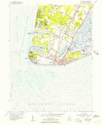
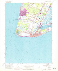
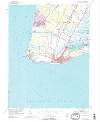
Editions of this 1954 Cape May Map
4 editions found
Other maps of this area

1888 · Cape May
USGS Topo · 1:62,500

1888 · Dennisville
USGS Topo · 1:62,500

1890 · Maurice Cove
USGS Topo · 1:62,500

1891 · Maurice Cove
USGS Topo · 1:62,500

1893 · Cape May
USGS Topo · 1:62,500

1894 · Dennisville
USGS Topo · 1:62,500

1898 · Cape May
USGS Topo · 1:62,500

1899 · Vineland
USGS Topo · 1:125,000

1918 · Cape Henlopen
USGS Topo · 1:62,500

1918 · Cape May
USGS Topo · 1:62,500