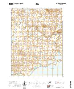
2020 Map of Cape Mendenhall D-3 NE
USGS Topo · Published 2020About this map
The coastal periphery of Nunivak Island meets the Bering Sea along the southern edge of this Bethel Census Area quadrangle. The landscape is characterized by a high concentration of small kettle lakes and wetlands, typical of the island's volcanic and tundra-covered interior. One of the most distinctive geological formations here is the Oongalambingoi Dunes, which dominate the southwestern shoreline where the land transitions to the sea. The map reveals a remote environment absent of modern roads or permanent settlements, defined instead by the complex drainage patterns and low-lying topography of the Bering Sea coast. Researchers of indigenous land use or Arctic geography can trace the intricate network of water bodies that shape this section of the island's southern reaches.
Find a feature on this map
6 named features on this map. Tap any name to fly to it.
Don’t see what you’re looking for? This feature index may not catch every label — zoom into the map to look around manually.
Map Details
Editions of this 2020 Cape Mendenhall D-3 NE Map
This is the sole edition of this map. No revisions or reprints were ever made.
Other maps of this area

1951 · Cape Mendenhall
USGS Topo · 1:250,000

1951 · Nunivak Island
USGS Topo · 1:250,000

1952 · Cape Mendenhall D-3
USGS Topo · 1:63,360

1952 · Cape Mendenhall
USGS Topo · 1:250,000
1952 · Cape Mendenhall D-2
USGS Topo · 1:63,360

1952 · Nunivak Island A-3
USGS Topo · 1:63,360
1952 · Nunivak Island A-2
USGS Topo · 1:63,360

1954 · Nunivak Island
USGS Topo · 1:250,000

1958 · Nunivak Island
USGS Topo · 1:250,000

1964 · Nunivak Island
USGS Topo · 1:250,000