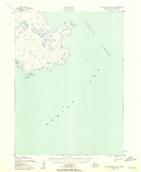
1952 Map of Cape Mendenhall D-2
USGS Topo · Published 1958About this map
Nunivak Island dominates this mid-century survey, revealing a landscape of coastal complexity within the Nunivak National Wildlife Refuge. The southeastern shoreline is defined by the waters of the Bering Sea and the Etolin Strait, where the terrain transitions from inland dunes to coastal Mud and Boulders. Small settlements like Nakooytoolekmiut appear along the south coast, providing a rare record of human geography in this remote maritime environment. Landforms such as Atahgo Point and Cape Corwin reach into the surrounding waters, which are marked with numerous foul and shoal warnings, indicating the treacherous navigation of the era. The map traces the precise topography of the island's interior through 50-foot contours, punctuated by survey markers like Vabm 80 and Vabm 52. This Army Map Service production offers a window into the Alaskan wilderness during a period of active photogrammetric mapping in the early 1950s.
Find a feature on this map
13 named features on this map. Tap any name to fly to it.
Don’t see what you’re looking for? This feature index may not catch every label — zoom into the map to look around manually.
Map Details
Editions of this 1952 Cape Mendenhall D-2 Map
2 editions found
Other maps of this area

1951 · Cape Mendenhall
USGS Topo · 1:250,000

1951 · Nunivak Island
USGS Topo · 1:250,000

1952 · Cape Mendenhall D-3
USGS Topo · 1:63,360

1952 · Cape Mendenhall
USGS Topo · 1:250,000

1952 · Nunivak Island A-3
USGS Topo · 1:63,360
1952 · Nunivak Island A-2
USGS Topo · 1:63,360

1954 · Nunivak Island
USGS Topo · 1:250,000

1958 · Nunivak Island
USGS Topo · 1:250,000

1964 · Nunivak Island
USGS Topo · 1:250,000
2020 · Nunivak Island A-3 SE
USGS Topo · 1:25,000