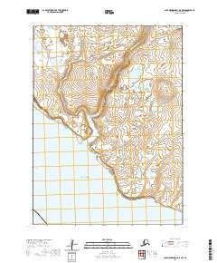
2020 Map of Cape Mendenhall D-5 NW
USGS Topo · Published 2020About this map
Jayalik Hill stands as the primary topographic landmark on this coastal section of the Bethel Census Area, overlooking a landscape defined by low-lying wetlands and wandering waterways. The Chakwakamiut River meanders across the northern reaches, while the south is dominated by the Jayalik River and its headwaters at Jayalik Lake. This 2020 survey records the intricate coastal geography where these freshwater systems meet the Bering Sea. The absence of developed roads or named settlements underscores the isolated character of this region, providing a clear record of the natural drainage patterns and shoreline morphology of southwest Alaska in the early twenty-first century. This data serves researchers monitoring coastal change and those studying the hydrography of the Yukon-Kuskokwim Delta region.
Find a feature on this map
9 named features on this map. Tap any name to fly to it.
Don’t see what you’re looking for? This feature index may not catch every label — zoom into the map to look around manually.
Map Details
Editions of this 2020 Cape Mendenhall D-5 NW Map
This is the sole edition of this map. No revisions or reprints were ever made.
Other maps of this area

1951 · Cape Mendenhall
USGS Topo · 1:250,000

1951 · Nunivak Island
USGS Topo · 1:250,000

1952 · Cape Mendenhall
USGS Topo · 1:250,000

1952 · Cape Mendenhall D-6
USGS Topo · 1:63,360

1952 · Nunivak Island A-6
USGS Topo · 1:63,360

1952 · Nunivak Island A-5
USGS Topo · 1:63,360
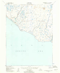
1952 · Cape Mendenhall D-5
USGS Topo · 1:63,360

1954 · Nunivak Island
USGS Topo · 1:250,000

1958 · Nunivak Island
USGS Topo · 1:250,000

1964 · Nunivak Island
USGS Topo · 1:250,000