
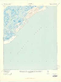
1943 Map of Capers Island
USGS Topo · Published 1943About this map
Capers Island and Dewees Island anchor this coastal survey, which details the intricate marshlands and tidal waterways of the South Carolina Lowcountry during the early 1940s. The landscape is defined by the dynamic movement of water through passages like Capers Inlet and Dewees Inlet, separating the barrier islands from the mainland marshes. Further inland, the map traces the winding paths of Toomer Creek and Whiteside Creek as they feed into the expansive Bullyard Sound. This era of the shoreline shows the northern reach of the Isle of Palms before mid-century development transformed the region. The map captures a transition point in coastal geography, documenting features like Santee Pass and Seven Reaches as they appeared just after being revised from 1941 aerial photography.
Find a feature on this map
15 named features on this map. Tap any name to fly to it.
Don’t see what you’re looking for? This feature index may not catch every label — zoom into the map to look around manually.
Map Details
Editions of this 1943 Capers Island Map
2 editions found
Other maps of this area

1919 · The Jetties
USGS Topo · 1:21,120

1919 · Capers Island
USGS Topo · 1:21,120

1919 · Wando
USGS Topo · 1:21,120

1919 · Fort Moultrie
USGS Topo · 1:21,120

1919 · Bulls Island
USGS Topo · 1:21,120

1919 · Sewee Bay
USGS Topo · 1:21,120

1943 · Fort Moultrie
USGS Topo · 1:24,000

1943 · Wando
USGS Topo · 1:24,000

1943 · Sewee Bay
USGS Topo · 1:24,000

1943 · Bulls Island
USGS Topo · 1:24,000