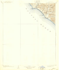
1902 Map of Capistrano
USGS Topo · Published 1939About this map
Capistrano and the surrounding coastline are captured here during a period of transition at the turn of the century, when large land grants like Mission Viejo and Santa Margarita Y Las Flores still defined the geography of southern Orange County. The landscape is dominated by steep coastal canyons and arroyos, including Arroyo San Mateo and Arroyo San Onofre, which cut through the hills toward the Pacific.
Find a feature on this map
22 named features on this map. Tap any name to fly to it.
Don’t see what you’re looking for? This feature index may not catch every label — zoom into the map to look around manually.
Map Details
Editions of this 1902 Capistrano Map
4 editions found
Other maps of this area

1893 · Oceanside
USGS Topo · 1:62,500

1896 · Santa Ana
USGS Topo · 1:62,500

1896 · Las Bolsas
USGS Topo · 1:62,500

1898 · Oceanside
USGS Topo · 1:62,500

1901 · Southern California Sheet No. 1
USGS Topo · 1:250,000

1901 · Santa Ana
USGS Topo · 1:62,500

1901 · Elsinore
USGS Topo · 1:125,000

1901 · Oceanside
USGS Topo · 1:62,500

1901 · San Luis Rey
USGS Topo · 1:125,000

1902 · Capistrano
USGS Topo · 1:125,000