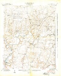
1941 Map of Capitol Hill
USGS Topo · Published 1944About this map
Camp Forrest Military Reservation dominates the northwestern landscape of this early 1940s survey, marking a period of intense military preparation. The Elk River winds through the center of the sheet, serving as a primary corridor for both infrastructure and community life. Significant industrial sites such as the Estill Springs Power Plant and the Camp Forrest Pumping Station illustrate the modernizing influence of the Tennessee Valley Authority and military development on this rural area.
Find a feature on this map
39 named features on this map. Tap any name to fly to it.
Don’t see what you’re looking for? This feature index may not catch every label — zoom into the map to look around manually.
Map Details
Editions of this 1941 Capitol Hill Map
3 editions found
Other maps of this area

1895 · Sewanee
USGS Topo · 1:125,000

1928 · Decherd
USGS Topo · 1:62,500

1936 · Ovoca
USGS Topo · 1:24,000

1936 · Sewanee
USGS Topo · 1:24,000

1936 · Alto
USGS Topo · 1:24,000

1936 · Manchester
USGS Topo · 1:24,000

1936 · Winchester
USGS Topo · 1:24,000

1936 · Hillsboro
USGS Topo · 1:24,000

1936 · Belvidere
USGS Topo · 1:24,000

1936 · Camp Peay
USGS Topo · 1:24,000