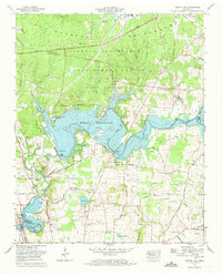
1972 Map of Capitol Hill
USGS Topo · Published 1973About this map
Arnold Engineering Development Center dominates the northern landscape of this survey, representing a significant Cold War-era aeronautical research installation within the U S Air Force reservation. This facility is integrated into a landscape of managed natural resources, including a large Wildlife Management Area and the University of Tennessee Space Institute situated along the shores of Woods Reservoir. The map illustrates a moment of hydraulic transformation, showing the Elk River harnessed by the Elk River Dam, while the southwest corner reveals the expanding reach of Tims Ford Lake.
Find a feature on this map
75 named features on this map. Tap any name to fly to it.
Don’t see what you’re looking for? This feature index may not catch every label — zoom into the map to look around manually.
Map Details
Editions of this 1972 Capitol Hill Map
4 editions found
Other maps of this area

1895 · Sewanee
USGS Topo · 1:125,000

1928 · Decherd
USGS Topo · 1:62,500

1936 · Ovoca
USGS Topo · 1:24,000

1936 · Sewanee
USGS Topo · 1:24,000

1936 · Alto
USGS Topo · 1:24,000

1936 · Manchester
USGS Topo · 1:24,000

1936 · Winchester
USGS Topo · 1:24,000

1936 · Hillsboro
USGS Topo · 1:24,000

1936 · Belvidere
USGS Topo · 1:24,000

1936 · Camp Peay
USGS Topo · 1:24,000