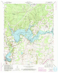
1972 Map of Capitol Hill
USGS Topo · Published 1993About this map
Woods Reservoir dominates this landscape on the Elk River, serving as a focal point for both military operations and local recreation. The reservoir is bound by the Elk River Dam, with the Arnold Air Force Base reservation extending across the northern portion of the map. This area, known as The Barrens, shows a complex integration of government facilities, including the University of Tennessee Space Institute, alongside established rural communities. South of the base, the terrain transitions into a patchwork of family-named cemeteries and small settlements like Estill Springs and Capitol Hill. The influence of the Louisville and Nashville railroad line and an old RR grade trace the historic transportation routes that preceded the massive water management projects of the Tennessee Valley Authority. Small water bodies like Lye Pond and Duncan Lake sit nestled among the ridges near Little Mountain, providing a glimpse into the natural drainage patterns of the region.
Find a feature on this map
60 named features on this map. Tap any name to fly to it.
Don’t see what you’re looking for? This feature index may not catch every label — zoom into the map to look around manually.
Map Details
Editions of this 1972 Capitol Hill Map
4 editions found
Other maps of this area

1895 · Sewanee
USGS Topo · 1:125,000

1928 · Decherd
USGS Topo · 1:62,500

1936 · Ovoca
USGS Topo · 1:24,000

1936 · Sewanee
USGS Topo · 1:24,000

1936 · Alto
USGS Topo · 1:24,000

1936 · Manchester
USGS Topo · 1:24,000

1936 · Winchester
USGS Topo · 1:24,000

1936 · Hillsboro
USGS Topo · 1:24,000

1936 · Belvidere
USGS Topo · 1:24,000

1936 · Camp Peay
USGS Topo · 1:24,000