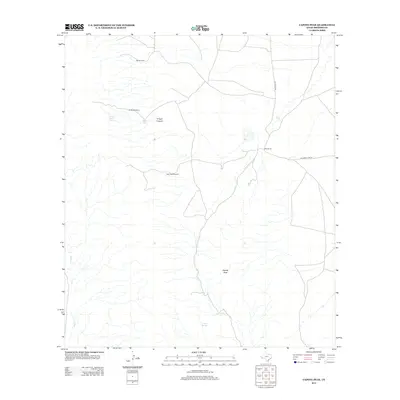
2012 Map of Capote Peak
USGS Topo · Published 2012About this map
Capote Peak stands as the central topographic focal point in this high-desert ranching landscape within Presidio County. The map details a sophisticated water-management system essential for desert life, from natural sources like Capote Springs and Trough Canyon Spring to human-made infrastructure including Hoya Tank, the Oil Well Windmill, and the Split Peak Windmill. These features indicate the ongoing reliance on groundwater to support remote outposts like Brite Ranch and Rancho Cielo. Transportation in this arid corridor is limited to a few arterial routes such as Old Brite Rd and Richards Gate Rd, which connect these isolated holdings through the drainage basins of Capote Cr and Walker Cr.
Find a feature on this map
13 named features on this map. Tap any name to fly to it.
Don’t see what you’re looking for? This feature index may not catch every label — zoom into the map to look around manually.
Map Details
Editions of this 2012 Capote Peak Map
This is the sole edition of this map. No revisions or reprints were ever made.
Other maps of this area

1895 · Marfa
USGS Topo · 1:125,000

1896 · San Carlos
USGS Topo · 1:125,000

1959 · Marfa
USGS Topo · 1:250,000

1965 · Marfa
USGS Topo · 1:250,000
1978 · Gettysburg Peak
USGS Topo · 1:24,000
1978 · Capote Peak
USGS Topo · 1:24,000
1979 · Nancy Anne Ranch
USGS Topo · 1:24,000

1979 · Capote Falls
USGS Topo · 1:24,000
1979 · Candelaria
USGS Topo · 1:24,000
1979 · McComb Canyon
USGS Topo · 1:24,000