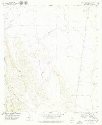
1979 Map of Nancy Anne Ranch
USGS Topo · Published 1979About this map
Nancy Anne Ranch and Old Chilcote Ranch serve as primary points of human presence in this high-desert landscape of Presidio County. The western edge of the quadrangle is defined by the sharp rise of the Sierra Vieja, where the terrain transitions from flat scrublands into a series of deeply etched drainage patterns including Howard Canyon and Walnut Canyon. The network of water sources, indicated by labels like Durazno Tank, White Well, and Red Well, underscores the vital infrastructure required for cattle ranching in this arid environment.
Find a feature on this map
16 named features on this map. Tap any name to fly to it.
Don’t see what you’re looking for? This feature index may not catch every label — zoom into the map to look around manually.
Map Details
Editions of this 1979 Nancy Anne Ranch Map
This is the sole edition of this map. No revisions or reprints were ever made.
Other maps of this area

1892 · Chispa
USGS Topo · 1:125,000

1894 · Valentine
USGS Topo · 1:125,000

1895 · Chispa
USGS Topo · 1:125,000

1895 · Marfa
USGS Topo · 1:125,000

1896 · San Carlos
USGS Topo · 1:125,000

1897 · Valentine
USGS Topo · 1:125,000

1897 · Chispa
USGS Topo · 1:125,000

1943 · Valentine
USGS Topo · 1:125,000

1959 · Marfa
USGS Topo · 1:250,000

1965 · Marfa
USGS Topo · 1:250,000