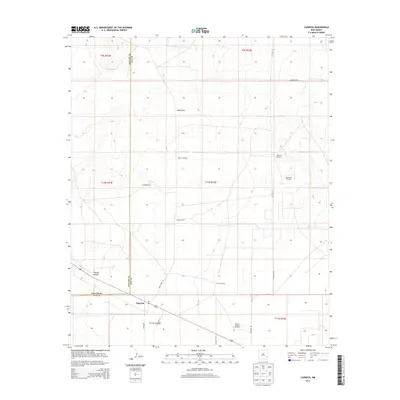
2013 Map of Caprock
USGS Topo · Published 2013About this map
Caprock anchors this high-plains landscape where the Chaves Co Lea Co border splits the terrain. The settlement pattern here is defined by water and oil, with numerous named windmills such as Section Windmill, Field Windmill, and Church Pasture Windmill supporting the cattle operations of the Caprock Ranch. In the eastern portion of the quadrangle, the industrial footprint of the Mescalero Oil Field becomes prominent, served by a network of local routes including Co Road 156. To the southwest, the topography breaks at Polecat Canyon, providing a rare geographic diversion from the regular township and range grid. This survey provides a precise look at the rural infrastructure of southeastern New Mexico, where deep-well water sources and petroleum extraction remain the primary drivers of human activity.
Find a feature on this map
23 named features on this map. Tap any name to fly to it.
Don’t see what you’re looking for? This feature index may not catch every label — zoom into the map to look around manually.
Map Details
Editions of this 2013 Caprock Map
This is the sole edition of this map. No revisions or reprints were ever made.
Other maps of this area

1954 · Brownfield
USGS Topo · 1:250,000

1958 · Brownfield
USGS Topo · 1:250,000

1962 · Brownfield
USGS Topo · 1:250,000

1973 · Mescalero Point
USGS Topo · 1:24,000

1973 · Soldier Hill
USGS Topo · 1:24,000

1973 · Caprock
USGS Topo · 1:24,000

1973 · Mescalero Point NE
USGS Topo · 1:24,000
1973 · Lane Salt Lake
USGS Topo · 1:24,000
1973 · Dallas Store
USGS Topo · 1:24,000

1978 · Flying M Ranch
USGS Topo · 1:24,000