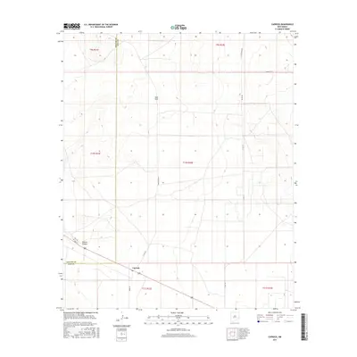
2017 Map of Caprock
USGS Topo · Published 2017About this map
Caprock serves as a small junction point in this high plains landscape of southeastern New Mexico, situated near the boundary between Chaves Co and Lea Co. The terrain is defined by its vast, open character and the presence of land features like Polecat Canyon, which cuts through the southwestern portion of the sheet. Modern infrastructure is represented by the path of Hwy 380, crossing the southern section near the settlement of Caprock. Local connectivity is provided by a network of ranch and access roads, including Hedgecoke Rd, Grose Rd, and Button Mesa Rd. The inclusion of Sand Gate further reflects the ranching operations and land divisions common to this part of the Llano Estacado, where property lines and survey townships such as t10s r32e organize the rural expanse.
Find a feature on this map
18 named features on this map. Tap any name to fly to it.
Don’t see what you’re looking for? This feature index may not catch every label — zoom into the map to look around manually.
Map Details
Editions of this 2017 Caprock Map
This is the sole edition of this map. No revisions or reprints were ever made.
Other maps of this area

1954 · Brownfield
USGS Topo · 1:250,000

1958 · Brownfield
USGS Topo · 1:250,000

1962 · Brownfield
USGS Topo · 1:250,000

1973 · Mescalero Point
USGS Topo · 1:24,000

1973 · Soldier Hill
USGS Topo · 1:24,000

1973 · Caprock
USGS Topo · 1:24,000

1973 · Mescalero Point NE
USGS Topo · 1:24,000
1973 · Lane Salt Lake
USGS Topo · 1:24,000
1973 · Dallas Store
USGS Topo · 1:24,000

1978 · Flying M Ranch
USGS Topo · 1:24,000