
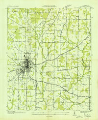
1936 Map of Capshaw
USGS Topo · Published 1936About this map
Limestone Creek winds through this 1930s landscape, serving as a focal point for a rural community structured around small schools and family-named landmarks. The area is defined by its transition from agricultural fields to early infrastructure, marked by multiple high-voltage lines including Alabama Power Company Transmission Line No 3. Notable social hubs of the era include Wesley Chapel and Capshaw, where the local Capshaw Sch and several country churches like New Zion Ch and Bethel Ch anchored the population.
Find a feature on this map
41 named features on this map. Tap any name to fly to it.
Don’t see what you’re looking for? This feature index may not catch every label — zoom into the map to look around manually.
Map Details
Editions of this 1936 Capshaw Map
This is the sole edition of this map. No revisions or reprints were ever made.
Other maps of this area

1888 · Huntsville
USGS Topo · 1:125,000

1892 · Huntsville
USGS Topo · 1:125,000
1935 · Athens
USGS Topo · 1:24,000

1936 · Jeff
USGS Topo · 1:24,000

1936 · Madison
USGS Topo · 1:24,000
1936 · Elkmont
USGS Topo · 1:24,000
1936 · Ardmore
USGS Topo · 1:24,000

1936 · Toney
USGS Topo · 1:24,000

1936 · Tanner
USGS Topo · 1:24,000

1936 · Greenbrier
USGS Topo · 1:24,000