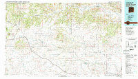
1982 Map of Capulin Mountain
USGS Topo · Published 1982About this map
The volcanic landscape of Union County is dominated by the distinctive profile of Capulin Mountain National Monument and the massive Sierra Grande shield volcano. This 1982 survey illustrates a transition from the rugged mesa country of the Dry Cimarron River valley in the north to the wide high plains to the south. Historically significant transportation routes converge here, most notably the legendary Santa Fe Trail and the Fort Union Road, which share the landscape with the Colorado and Southern railroad line. Small prairie settlements like Folsom, Des Moines, and Grenville anchor the local ranching economy. The map also captures the Four Corners-adjacent borders where New Mexico meets Colorado, Oklahoma, and Texas, featuring landforms like Rabbit Ear Mountain and the expansive Black Mesa State Park near the state lines.
Find a feature on this map
76 named features on this map. Tap any name to fly to it.
Don’t see what you’re looking for? This feature index may not catch every label — zoom into the map to look around manually.
Map Details
Editions of this 1982 Capulin Mountain Map
2 editions found
Other maps of this area

1891 · Springfield
USGS Topo · 1:125,000

1891 · Mesa De Maya
USGS Topo · 1:125,000

1892 · Elmoro
USGS Topo · 1:125,000

1892 · Mt Carrizo
USGS Topo · 1:125,000

1893 · Elmoro
USGS Topo · 1:125,000

1893 · Springfield
USGS Topo · 1:125,000

1893 · Mesa de Maya
USGS Topo · 1:125,000

1897 · Elmoro
USGS Topo · 1:125,000

1954 · Raton
USGS Topo · 1:250,000

1954 · Trinidad
USGS Topo · 1:250,000