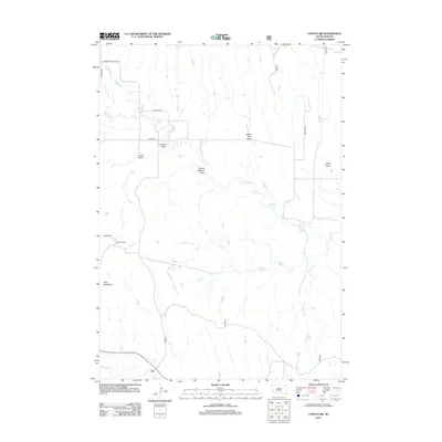
2012 Map of Caputa SW
USGS Topo · Published 2012About this map
Spring Cr meanders through this Pennington County landscape, defining a network of drainages and ranching lands southeast of Rapid City. The terrain is marked by a series of named draws and gulches, such as School Section Draw, Indian Trail Draw, and Lauzon Gulch, which reflect the historical use and naming of the local topography. At the center of the regional activity sits the Lauzon Ranch, located near the intersection of Baker Rd and the winding creek bed. To the southwest, Flag Mountain rises as a distinct landmark above the junction of several ephemeral streams including Battle Cr and Willow Cr. This 2012 survey illustrates the modern road network, including Co Hwy-10 and Co Hwy-924, which provide access to these remote draws and agricultural homesteads.
Find a feature on this map
17 named features on this map. Tap any name to fly to it.
Don’t see what you’re looking for? This feature index may not catch every label — zoom into the map to look around manually.
Map Details
Editions of this 2012 Caputa SW Map
This is the sole edition of this map. No revisions or reprints were ever made.
Other maps of this area

1894 · Hermosa
USGS Topo · 1:125,000

1901 · Hermosa
USGS Topo · 1:125,000

1951 · Red Shirt
USGS Topo · 1:24,000

1951 · Red Shirt NE
USGS Topo · 1:24,000

1953 · Caputa
USGS Topo · 1:24,000

1953 · Hermosa SE
USGS Topo · 1:24,000

1953 · Folsom
USGS Topo · 1:24,000
1953 · Hermosa NE
USGS Topo · 1:24,000

1953 · Caputa NE
USGS Topo · 1:24,000

1953 · Caputa SW
USGS Topo · 1:24,000