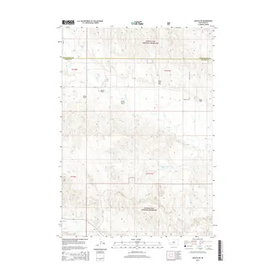
2015 Map of Caputa SW
USGS Topo · Published 2015About this map
The Buffalo Gap National Grassland dominates this landscape along the border of Pennington and Custer Counties, reflecting the expansive public grazing lands characteristic of southwestern South Dakota. The terrain is defined by a series of named drainages and coulees, including Charles Draw, School Section Draw, and Indian Trail Draw, which channel seasonal runoff toward larger watercourses like Spring Cr and Battle Cr. These landforms, along with the prominent Flag Mtn, highlight the complex topography used by generations of ranchers and travelers. The presence of Prairie View Rd and Cr-152 provides context for local transit through this largely unpopulated ranching territory, where the physical features often dictated the placement of section lines and transport corridors.
Find a feature on this map
18 named features on this map. Tap any name to fly to it.
Don’t see what you’re looking for? This feature index may not catch every label — zoom into the map to look around manually.
Map Details
Editions of this 2015 Caputa SW Map
This is the sole edition of this map. No revisions or reprints were ever made.
Other maps of this area

1894 · Hermosa
USGS Topo · 1:125,000

1901 · Hermosa
USGS Topo · 1:125,000

1951 · Red Shirt
USGS Topo · 1:24,000

1951 · Red Shirt NE
USGS Topo · 1:24,000

1953 · Caputa
USGS Topo · 1:24,000

1953 · Hermosa SE
USGS Topo · 1:24,000

1953 · Folsom
USGS Topo · 1:24,000
1953 · Hermosa NE
USGS Topo · 1:24,000

1953 · Caputa NE
USGS Topo · 1:24,000

1953 · Caputa SW
USGS Topo · 1:24,000