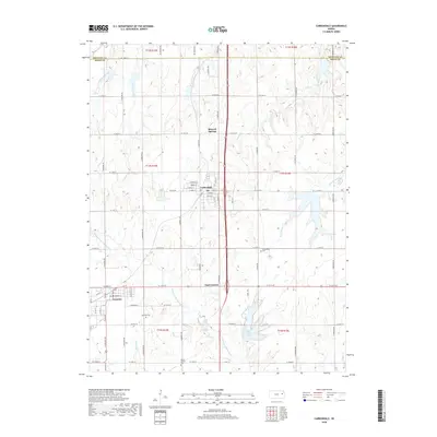
2018 Map of Carbondale
USGS Topo · Published 2018About this map
Carbondale and Scranton serve as the primary hubs of this northeast Osage County landscape, situated along the border with Shawnee County. The map reveals a transition between the organized grid of these towns—notably the residential blocks along W Main St and Osage St—and the undulating creek valleys that define the surrounding prairie. Significant water features such as Hundred and Ten Mile Cr and Strowbridge Cr branch across the territory, with the man-made Osage County Lake providing a focal point for the local geography south of Carbondale. This 2018 survey also carefully documents local heritage sites, including the Carbondale Cem and Mount Calvary Cem, providing essential markers for researchers tracing family history in the area. The presence of smaller settlements like Mineral Springs and Four Corners indicates the persistent network of rural communities that support this region's agricultural and residential character.
Find a feature on this map
63 named features on this map. Tap any name to fly to it.
Don’t see what you’re looking for? This feature index may not catch every label — zoom into the map to look around manually.
Map Details
Editions of this 2018 Carbondale Map
This is the sole edition of this map. No revisions or reprints were ever made.
Other maps of this area

1889 · Burlingame
USGS Topo · 1:125,000

1894 · Burlingame
USGS Topo · 1:125,000

1947 · Lawrence
USGS Topo · 1:250,000

1950 · Lawrence
USGS Topo · 1:250,000

1952 · Auburn
USGS Topo · 1:24,000

1952 · Burlingame
USGS Topo · 1:24,000
1955 · Wakarusa
USGS Topo · 1:24,000

1955 · Overbrook
USGS Topo · 1:24,000

1955 · Carbondale
USGS Topo · 1:24,000
1955 · Richland
USGS Topo · 1:24,000