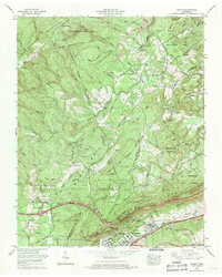
1968 Map of Cardiff
USGS Topo · Published 1971About this map
The Mt Roosevelt State Forest and Catoosa Wildlife Management Area dominate this section of the Cumberland Plateau, where the landscape transitions from high ridges to the industrial and transportation corridors of the valley. In the late 1960s, the area around Rockwood and Cardiff shows a complex network of resource extraction and infrastructure, including numerous strip mines and the Southern railway line. Transportation history is layered here, with the Old Walton Road and the Broadway of America traversing the terrain near Westel Community Center. The map is particularly useful for genealogists, as it identifies more than a dozen local burying grounds, such as Skidmore Cem, Piney Cem, and Farmer Cem, alongside community landmarks like Mt Pisgah Church and the Rockwood Municipal Airport.
Find a feature on this map
93 named features on this map. Tap any name to fly to it.
Don’t see what you’re looking for? This feature index may not catch every label — zoom into the map to look around manually.
Map Details
Editions of this 1968 Cardiff Map
4 editions found
Other maps of this area

1887 · Kingston
USGS Topo · 1:125,000

1891 · Kingston
USGS Topo · 1:125,000

1893 · Kingston
USGS Topo · 1:125,000

1895 · Wartburg
USGS Topo · 1:125,000

1896 · Wartburg
USGS Topo · 1:125,000

1935 · Rockwood
USGS Topo · 1:24,000

1935 · Camp Austin
USGS Topo · 1:24,000

1935 · Harriman
USGS Topo · 1:24,000

1935 · Lancing
USGS Topo · 1:24,000

1936 · Hebbertsburg
USGS Topo · 1:24,000