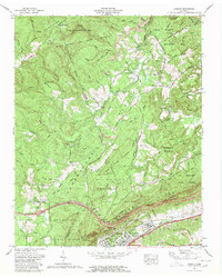
1968 Map of Cardiff
USGS Topo · Published 1980About this map
The Cumberland Plateau and the Crab Orchard Mountains converge in this 1968 revision, which captures the industrial and transportation corridor along the Roane and Cumberland county line. The city of Rockwood serves as the primary hub, where the Southern railway and the historic Broadway of America highway trace the base of Walden Ridge. To the east, the settlement of Cardiff and the Roane Memorial Gardens mark the transition toward the valley floor, while the heights above are occupied by the Mt Roosevelt State Forest.
Find a feature on this map
93 named features on this map. Tap any name to fly to it.
Don’t see what you’re looking for? This feature index may not catch every label — zoom into the map to look around manually.
Map Details
Editions of this 1968 Cardiff Map
4 editions found
Other maps of this area

1887 · Kingston
USGS Topo · 1:125,000

1891 · Kingston
USGS Topo · 1:125,000

1893 · Kingston
USGS Topo · 1:125,000

1895 · Wartburg
USGS Topo · 1:125,000

1896 · Wartburg
USGS Topo · 1:125,000

1935 · Rockwood
USGS Topo · 1:24,000

1935 · Camp Austin
USGS Topo · 1:24,000

1935 · Harriman
USGS Topo · 1:24,000

1935 · Lancing
USGS Topo · 1:24,000

1936 · Hebbertsburg
USGS Topo · 1:24,000