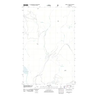
2011 Map of Caribou Creek
USGS Topo · Published 2011About this map
Upper Priest Lake Scenic Area and the northeastern shores of Upper Priest Lake anchor this 2011 survey of Bonner County's high country. The landscape is defined by its complex drainage systems, where Caribou Creek and Bugle Creek descend from high ridges toward the valley floor. Notable landmarks such as Phoebe Tip, Caribou Hill, and Lookout Mountain provide significant vertical relief, while smaller water bodies like Mollies Lake and the Caribou Lakes are tucked into the higher elevations. The presence of Caribou Falls and a Waterfall along the creek suggests the steep gradients of the local terrain. Access is limited to a network of forest roads including Bugle Creek Rd and East Shore Rd, reflecting the remote and managed character of this protected forest and parkland near Priest Lake State Park.
Find a feature on this map
22 named features on this map. Tap any name to fly to it.
Don’t see what you’re looking for? This feature index may not catch every label — zoom into the map to look around manually.
Map Details
Editions of this 2011 Caribou Creek Map
This is the sole edition of this map. No revisions or reprints were ever made.
Other maps of this area

1911 · Priest Lake
USGS Topo · 1:250,000

1913 · Priest Lake
USGS Topo · 1:250,000

1958 · Sandpoint
USGS Topo · 1:250,000

1963 · Sandpoint
USGS Topo · 1:250,000

1967 · Priest Lake NE
USGS Topo · 1:24,000

1967 · Priest Lake NW
USGS Topo · 1:24,000

1967 · The Wigwams
USGS Topo · 1:24,000
1968 · Continental Mtn
USGS Topo · 1:24,000

1969 · Grass Mountain
USGS Topo · 1:24,000
1969 · Caribou Creek
USGS Topo · 1:24,000