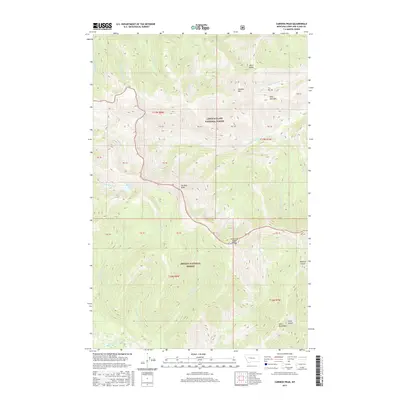
2017 Map of Caribou Peak
USGS Topo · Published 2017About this map
Caribou Peak anchors this section of the Continental Divide where the Lewis & Clark National Forest meets the Helena National Forest. The landscape is defined by the complex hydrology of the Lewis and Clark Range, which sends waters toward the Missouri and Columbia basins. Notable high-altitude water bodies like Bighorn Lake sit beneath peaks such as Monitor Mtn and Bear Den Mtn. The drainage patterns are intricate, featuring colorfully named tributaries like Baking Powder Cr, No Grass Cr, and Fickler Cr. To the south, the terrain descends toward the Landers Fork, passing through a series of steep drainages including Skull Gulch and Toms Gulch near the Alice Mountains. This 2017 survey shows the managed forest boundaries and the network of forest service routes that provide access to these high-country basins and the Middle Fork Falls Cr corridor.
Find a feature on this map
41 named features on this map. Tap any name to fly to it.
Don’t see what you’re looking for? This feature index may not catch every label — zoom into the map to look around manually.
Map Details
Editions of this 2017 Caribou Peak Map
This is the sole edition of this map. No revisions or reprints were ever made.
Other maps of this area

1903 · Coopers Lake
USGS Topo · 1:125,000

1943 · Hogan
USGS Topo · 1:125,000

1955 · Choteau
USGS Topo · 1:250,000

1957 · Choteau
USGS Topo · 1:250,000

1958 · Choteau
USGS Topo · 1:250,000

1962 · Choteau
USGS Topo · 1:250,000
1963 · Cadotte Creek
USGS Topo · 1:24,000
1963 · Blowout Mountain
USGS Topo · 1:24,000
1963 · Bean Lake
USGS Topo · 1:24,000

1968 · Heart Lake
USGS Topo · 1:24,000