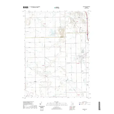
2019 Map of Carleton
USGS Topo · Published 2019About this map
Carleton and the surrounding agricultural landscapes of northern Monroe County are defined by an intricate network of drainage channels that have reclaimed this low-lying terrain for farming. Named features like the John Hoffman Drain, Lords Drain, and Mosquito Drain intersect the countryside, supporting a string of historic railroad-adjacent settlements including Waltz, Willow, and Grafton. The importance of these small communities is evidenced by their established local landmarks, from the Buzzwick Airport to a high concentration of burial grounds such as Saint Patricks Cem and Grafton Cem. The topography remains relatively flat as the waters of Stony Cr and Swan Cr move toward the lake, leaving a detailed record of land use and property boundaries along roads like Oakville Waltz Rd and Scofield Carleton Rd.
Find a feature on this map
96 named features on this map. Tap any name to fly to it.
Don’t see what you’re looking for? This feature index may not catch every label — zoom into the map to look around manually.
Map Details
Editions of this 2019 Carleton Map
This is the sole edition of this map. No revisions or reprints were ever made.
Other maps of this area

1902 · Ypsilanti
USGS Topo · 1:62,500

1904 · Ann Arbor
USGS Topo · 1:125,000

1906 · Ypsilanti
USGS Topo · 1:62,500

1906 · Romulus
USGS Topo · 1:62,500

1908 · Ann Arbor
USGS Topo · 1:125,000

1912 · Monroe
USGS Topo · 1:62,500

1912 · Dundee
USGS Topo · 1:62,500

1914 · Monroe
USGS Topo · 1:62,500

1926 · Dundee
USGS Topo · 1:62,500

1927 · Monroe
USGS Topo · 1:31,680
Featured Places
- Frenchtown Charter Township, MI
- Huron Charter Township, MI
- Sumpter Township, MI
- Ash Township, MI
- Raisinville Township, MI