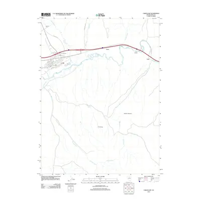
2012 Map of Carlin East
USGS Topo · Published 2012About this map
Carlin sits at the northern edge of the Pinon Range where the Humboldt River carves through the landscape, serving as a primary transportation hub for Elko County. This 2012 survey details the local infrastructure, from the Central Carlin Interchange to the Carlin Post Office and the Carlin Cemetery, while also capturing more remote agricultural landmarks like the Red House Ranch. The confluence of river and road is most dramatic at Carlin Canyon, where the modern interstate follows the ancient path of the water. To the north, historical routes like the Greenhorn Cutoff and Tuscarora Rd trace the path of earlier travelers through the desert. Small settlements and former rail sidings like Vivian and Tonka line the river valley, while the southern terrain rises toward Buckskin Mountain, punctuated by isolated water sources such as Rye Patch Spring.
Find a feature on this map
23 named features on this map. Tap any name to fly to it.
Don’t see what you’re looking for? This feature index may not catch every label — zoom into the map to look around manually.
Map Details
Editions of this 2012 Carlin East Map
This is the sole edition of this map. No revisions or reprints were ever made.
Other maps of this area

1952 · Dixie Flats
USGS Topo · 1:62,500

1952 · Carlin
USGS Topo · 1:62,500

1955 · Winnemucca
USGS Topo · 1:250,000

1955 · Elko
USGS Topo · 1:250,000

1958 · Winnemucca
USGS Topo · 1:250,000

1958 · Elko
USGS Topo · 1:250,000

1958 · Hunter
USGS Topo · 1:24,000

1958 · Huntsman Ranch
USGS Topo · 1:24,000

1962 · Elko
USGS Topo · 1:250,000

1962 · Winnemucca
USGS Topo · 1:250,000