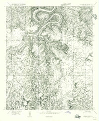
1955 Map of Carlisle 3 NE
USGS Topo · Published 1956About this map
The Colorado River carves a massive, looping gooseneck through the northern portion of this canyonlands landscape, providing a stark hydrological contrast to the desert drainages that define the rest of the terrain. To the south and east, the drainage networks of Elephant Canyon and Squaw Canyon reveal an intricate system of sandstone erosion, while the broad expanse of Squaw Flat offers a rare level bench above the surrounding gorges.
Find a feature on this map
13 named features on this map. Tap any name to fly to it.
Don’t see what you’re looking for? This feature index may not catch every label — zoom into the map to look around manually.
Map Details
Editions of this 1955 Carlisle 3 NE Map
This is the sole edition of this map. No revisions or reprints were ever made.
Other maps of this area

1885 · La Sal
USGS Topo · 1:250,000

1951 · Upheaval Dome
USGS Topo · 1:62,500

1952 · Carlisle 2 SE
USGS Topo · 1:24,000

1952 · Carlisle 2 SW
USGS Topo · 1:24,000

1953 · Carlisle 3 NW
USGS Topo · 1:24,000

1953 · The Needles
USGS Topo · 1:62,500

1954 · Carlisle 4 SW
USGS Topo · 1:24,000

1954 · Carlisle 4 NW
USGS Topo · 1:24,000

1954 · Carlisle 1 SW
USGS Topo · 1:24,000
1954 · Harts Point
USGS Topo · 1:62,500