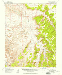
1954 Map of Harts Point
USGS Topo · Published 1958About this map
Indian Creek carves through the heart of this landscape, anchoring a network of canyons and high plateaus in San Juan County. In the mid-1950s, Dugout Ranch stands as a primary hub of activity in this arid region, situated near the confluence of several prominent drainages. The map details a landscape where ancient human history and modern ranching coexist, noting the presence of a Cliff Dwelling and Petroglyphs alongside contemporary features like a remote Landing Strip and multiple Prospect sites. Notable summits such as North Six-shooter Peak and South Six-shooter Peak rise above the complex terrain of Corral Pocket and Big Pocket. Significant topographic landmarks including Harts Draw, Jacks Mesa, and Bridger Jack Mesa define the local relief, while a Natural Arch is recorded near the head of Lavender Canyon.
Find a feature on this map
43 named features on this map. Tap any name to fly to it.
Don’t see what you’re looking for? This feature index may not catch every label — zoom into the map to look around manually.
Map Details
Editions of this 1954 Harts Point Map
4 editions found

Other maps of this area

1885 · La Sal
USGS Topo · 1:250,000

1886 · Abajo
USGS Topo · 1:250,000

1892 · Abajo
USGS Topo · 1:250,000

1893 · Abajo
USGS Topo · 1:250,000

1935 · Elk Ridge
USGS Topo · 1:96,000

1940 · Elk Ridge
USGS Topo · 1:125,000

1951 · Upheaval Dome
USGS Topo · 1:62,500

1952 · Carlisle 2 SE
USGS Topo · 1:24,000

1953 · The Needles
USGS Topo · 1:62,500

1954 · Elk Ridge 1 NW
USGS Topo · 1:24,000