
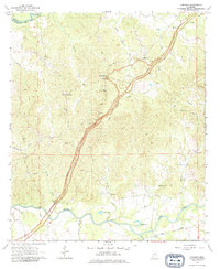
1963 Map of Carlisle
USGS Topo · Published 1964About this map
The Natchez Trace Parkway bisects the wooded hills and creek bottoms of Claiborne County in the early 1960s, following a historic travel corridor between the Big Black River and Bayou Pierre. The settlement of Rocky Springs stands as a focal point in the northern section, while the southern landscape is defined by the Illinois Central railroad corridor passing through Carlisle. This survey details a rural Mississippi environment where community life centered on locations like Midway Ch, Bethel Green Ch, and St Lukes Ch. The topography reveals the intricate drainage of Little Sand Creek and Booths Creek, punctuated by industrial activity such as several Gravel Pits and an Oil Well. Family history is anchored by the Flowers Cem and Templeton Cem, providing valuable touchpoints for genealogical research in this river-bound region.
Find a feature on this map
31 named features on this map. Tap any name to fly to it.
Don’t see what you’re looking for? This feature index may not catch every label — zoom into the map to look around manually.
Map Details
Editions of this 1963 Carlisle Map
2 editions found
Other maps of this area

1939 · Yokena
USGS Topo · 1:62,500

1953 · Natchez
USGS Topo · 1:250,000

1955 · Jackson
USGS Topo · 1:250,000

1956 · Natchez
USGS Topo · 1:250,000

1959 · Natchez
USGS Topo · 1:250,000

1961 · Jackson
USGS Topo · 1:250,000

1962 · Jackson
USGS Topo · 1:250,000

1962 · Utica West
USGS Topo · 1:24,000

1963 · Port Gibson
USGS Topo · 1:24,000

1963 · Dentville NW
USGS Topo · 1:24,000