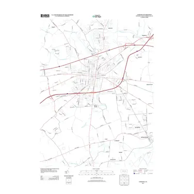
2013 Map of Carlisle
USGS Topo · Published 2013About this map
Boiling Springs and the surrounding Cumberland Valley landscape are defined by a complex network of limestone-influenced waterways, including the winding Yellow Breeches Cr and Letort Spring Run. This 2013 survey illustrates the dense integration of the regional hub, showing the expansion of Carlisle alongside established crossroads such as Middlesex and Mount Zion. The map highlights important local landmarks including the Carlisle Fairgrounds and Carlisle Airport, which sit adjacent to the intricate road network of the Carlisle Pike and Harrisburg Pike. North of the town center, the Conodoguinet Cr snakes through the valley near Cave Hill and Caprivi, while recreational and historical sites like Camp Shand are noted on the periphery. The terrain is marked by significant spring-fed hydrology, with the Letort Spring and Spring Run feeding into the larger creek systems that have shaped the agriculture and settlement patterns of this central Pennsylvania region for generations.
Find a feature on this map
181 named features on this map. Tap any name to fly to it.
Don’t see what you’re looking for? This feature index may not catch every label — zoom into the map to look around manually.
Map Details
Editions of this 2013 Carlisle Map
This is the sole edition of this map. No revisions or reprints were ever made.
Other maps of this area

1904 · Carlisle
USGS Topo · 1:62,500

1907 · New Bloomfield
USGS Topo · 1:62,500

1919 · Newville
USGS Topo · 1:62,500

1930 · Loysville
USGS Topo · 1:62,500

1933 · Loysville
USGS Topo · 1:62,500

1943 · New Bloomfield
USGS Topo · 1:62,500

1943 · Carlisle
USGS Topo · 1:62,500

1945 · Newville
USGS Topo · 1:62,500

1950 · Harrisburg
USGS Topo · 1:250,000
1952 · Dickinson
USGS Topo · 1:24,000
Featured Places
- Carlisle, PA
- Middlesex Township, PA
- Schlusser, PA
- Boiling Springs, South Middleton Township
- West Pennsboro Township, PA