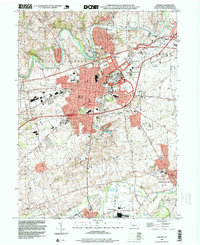
1994 Map of Carlisle
USGS Topo · Published 1999About this map
Carlisle serves as the central hub of this Pennsylvania landscape, where the dense grid of the borough meets the sprawling Carlisle Barracks and the Carlisle Fairgrounds. The topography is defined by the winding course of Conodoguinet Creek to the north and Yellow Breeches Creek to the south, framing a region defined by historical institutions and agricultural transitions. Genealogists will find significant detail in the numerous burial sites, from Union Cem and Westminster Cem to the County Home Cem east of town.
Find a feature on this map
50 named features on this map. Tap any name to fly to it.
Don’t see what you’re looking for? This feature index may not catch every label — zoom into the map to look around manually.
Map Details
Editions of this 1994 Carlisle Map
This is the sole edition of this map. No revisions or reprints were ever made.
Other maps of this area

1904 · Carlisle
USGS Topo · 1:62,500

1907 · New Bloomfield
USGS Topo · 1:62,500

1919 · Newville
USGS Topo · 1:62,500

1930 · Loysville
USGS Topo · 1:62,500

1933 · Loysville
USGS Topo · 1:62,500

1943 · New Bloomfield
USGS Topo · 1:62,500

1943 · Carlisle
USGS Topo · 1:62,500

1945 · Newville
USGS Topo · 1:62,500

1950 · Harrisburg
USGS Topo · 1:250,000
1952 · Dickinson
USGS Topo · 1:24,000
Featured Places
- Carlisle, PA
- Middlesex Township, PA
- Schlusser, PA
- Boiling Springs, South Middleton Township
- West Pennsboro Township, PA