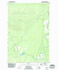
1955 Map of Carlisle
USGS Topo · Published 1995About this map
The timber and rail infrastructure of coastal Grays Harbor County defines this mid-century landscape. The settlement of Carlisle serves as a central hub, flanked by Carlisle West and Carlisle East. The map reveals a transition from active industry to secondary use, marked by the extensive Old Railroad Grade and Carlisle Grade that snake through the lowlands. These corridors once connected the logging interior to the coast, passing near the southern boundary of the Quinault Indian Res.
Find a feature on this map
21 named features on this map. Tap any name to fly to it.
Don’t see what you’re looking for? This feature index may not catch every label — zoom into the map to look around manually.
Map Details
Editions of this 1955 Carlisle Map
4 editions found
Other maps of this area

1921 · Quinault Lake
USGS Topo · 1:62,500

1938 · Moclips
USGS Topo · 1:62,500

1941 · Moclips
USGS Topo · 1:62,500

1943 · Humptulips
USGS Topo · 1:62,500

1943 · Copalis Beach
USGS Topo · 1:250,000

1951 · Copalis Beach
USGS Topo · 1:250,000

1955 · Macafee Hill
USGS Topo · 1:62,500

1955 · Humptulips
USGS Topo · 1:62,500

1955 · Quinault Lake
USGS Topo · 1:62,500

1955 · Carlisle
USGS Topo · 1:24,000