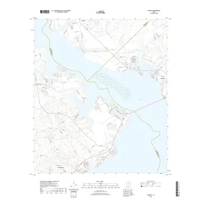
2019 Map of Carlisle
USGS Topo · Published 2019About this map
Lake Livingston dominates this East Texas landscape, its sprawling inlets defining the boundaries between Trinity, San Jacinto, and Polk Counties. On the eastern shore, the town of Onalaska shows a dense network of residential streets such as Edgewood and Oak Park Trl, contrasting with the more dispersed settlements of Carlisle and Point Blank to the west. The terrain is marked by numerous drainage systems including Palmetto Cr, Rocky Cr, and Mill Cr, which feed into the primary reservoir. Historical interest is centered near the southern edge of the sheet, where Liberty Hill serves as a local anchor with the Liberty Ch and Liberty Hill Cem providing vital points for genealogical research. The map also illustrates the varied topography leading up to Darby Hill, showing how modern residential development and FM 356 have integrated with the older rural land patterns of the Piney Woods.
Find a feature on this map
111 named features on this map. Tap any name to fly to it.
Don’t see what you’re looking for? This feature index may not catch every label — zoom into the map to look around manually.
Map Details
Editions of this 2019 Carlisle Map
This is the sole edition of this map. No revisions or reprints were ever made.
Other maps of this area

1954 · Beaumont
USGS Topo · 1:250,000

1957 · Beaumont
USGS Topo · 1:250,000

1960 · Blanchard
USGS Topo · 1:24,000

1960 · Colita
USGS Topo · 1:24,000

1960 · Trinity East
USGS Topo · 1:24,000

1960 · Carlisle
USGS Topo · 1:24,000

1960 · Stephen Creek
USGS Topo · 1:24,000

1961 · Staley
USGS Topo · 1:24,000

1961 · Onalaska
USGS Topo · 1:24,000

1961 · Oakhurst
USGS Topo · 1:24,000