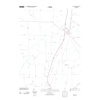
2013 Map of Carlisle
USGS Topo · Published 2013About this map
Carlisle serves as the central hub of this Indiana landscape, where a grid of rural roads and historical routes like S Old Buffalo Trl cross the agricultural plains of Sullivan County. The town's layout is clearly defined by streets such as W Saline St and N Alexander St, while the surrounding countryside is marked by an extensive network of drainage and creek systems. To the south, the Ridgway Flying Service Airport provides a point of modern infrastructure amidst the fields. The drainage of the area is particularly complex, featuring the meandering paths of Busseron Cr and Marsh Cr, alongside managed waterways like the Shaker Prairie Ditch. This geography highlights the intensive land management required for the region's agricultural productivity, tracing the legacy of how water was moved to clear the prairie for settlement and farming.
Find a feature on this map
83 named features on this map. Tap any name to fly to it.
Don’t see what you’re looking for? This feature index may not catch every label — zoom into the map to look around manually.
Map Details
Editions of this 2013 Carlisle Map
This is the sole edition of this map. No revisions or reprints were ever made.
Other maps of this area

1917 · Birds
USGS Topo · 1:62,500

1942 · Birds
USGS Topo · 1:62,500

1943 · Merom
USGS Topo · 1:24,000

1943 · Carlisle
USGS Topo · 1:24,000

1943 · Oaktown
USGS Topo · 1:24,000

1943 · Bicknell
USGS Topo · 1:24,000

1943 · Sullivan
USGS Topo · 1:24,000

1943 · Dugger
USGS Topo · 1:24,000

1944 · Bucktown
USGS Topo · 1:24,000
1952 · Dugger
USGS Topo · 1:24,000