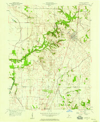
1957 Map of Carlisle
USGS Topo · Published 1958About this map
Carlisle serves as a central hub for the surrounding farmlands of Sullivan and Knox counties, situated along the Chicago and Eastern Illinois railroad line. The landscape is defined by the winding course of Busseron Creek and marked by the historic Vincennes Tract Boundary, which cuts diagonally across the northern sections. This era of the late 1950s highlights a rural community anchored by numerous family and community burial grounds, such as Odd Fellows Cem, Old Town Cem, and Ledgerwood Cem, reflecting generations of local settlement. Religious life is rooted in landmarks like Shaker Prairie Ch and Morris Chapel. The presence of Gas Storage Bins and a Gas Storage Well indicate the importance of underground energy infrastructure to the local economy alongside traditional agriculture.
Find a feature on this map
32 named features on this map. Tap any name to fly to it.
Don’t see what you’re looking for? This feature index may not catch every label — zoom into the map to look around manually.
Map Details
Editions of this 1957 Carlisle Map
This is the sole edition of this map. No revisions or reprints were ever made.
Other maps of this area

1917 · Birds
USGS Topo · 1:62,500

1942 · Birds
USGS Topo · 1:62,500

1943 · Merom
USGS Topo · 1:24,000

1943 · Carlisle
USGS Topo · 1:24,000

1943 · Oaktown
USGS Topo · 1:24,000

1943 · Bicknell
USGS Topo · 1:24,000

1943 · Sullivan
USGS Topo · 1:24,000

1943 · Dugger
USGS Topo · 1:24,000

1944 · Bucktown
USGS Topo · 1:24,000
1952 · Dugger
USGS Topo · 1:24,000