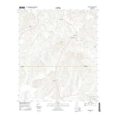
2014 Map of Carlowville
USGS Topo · Published 2014About this map
The boundary between Dallas Co and Wilcox Co divides this rural landscape, which is defined by a network of small agricultural settlements and winding watercourses. Richmond sits in the north, while the village of Carlowville serves as a local hub near Carlowville Community Cemetery and Saint Pauls Cemetery. The terrain is shaped by the drainage basins of several prominent creeks, including Swift Creek, Snake Creek, and Institute Creek, which flow through the dissected uplands marked by elevations like Morgan Hill and Wildcat Hill. The road network, including Al-89, connects these higher ridges with southern outposts like Ackerville and Snow Hill, situated near the wide basin of Pine Barren Creek. This survey captures the enduring settlement patterns of Alabama’s Black Belt, where community life remains centered around established family crossroads and parish burial grounds.
Find a feature on this map
39 named features on this map. Tap any name to fly to it.
Don’t see what you’re looking for? This feature index may not catch every label — zoom into the map to look around manually.
Map Details
Editions of this 2014 Carlowville Map
This is the sole edition of this map. No revisions or reprints were ever made.
Other maps of this area

1953 · Montgomery
USGS Topo · 1:250,000

1953 · Andalusia
USGS Topo · 1:250,000

1956 · Montgomery
USGS Topo · 1:250,000

1957 · Montgomery
USGS Topo · 1:250,000

1957 · Andalusia
USGS Topo · 1:250,000

1957 · Carlowville
USGS Topo · 1:62,500

1957 · Braggs
USGS Topo · 1:62,500

1975 · Carlowville NE
USGS Topo · 1:24,000
1975 · Carlowville NW
USGS Topo · 1:24,000
1981 · Rosebud
USGS Topo · 1:24,000