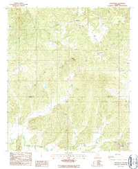
1987 Map of Carlowville
USGS Topo · Published 1987About this map
Carlowville and Richmond anchor this southern Alabama landscape during the late twentieth century, where the rural character of the Dallas Co Wilcox Co boundary is defined by winding watercourses and small-scale extractive industries. The terrain is marked by prominent elevations like Ethridge Ridge and Wildcat Hill, while the local economy is evidenced by scattered Clay Pit and Gravel Pit operations. Several unnamed Cem locations are noted near the primary settlements, providing valuable points of interest for genealogical research in these long-established communities.
Find a feature on this map
19 named features on this map. Tap any name to fly to it.
Don’t see what you’re looking for? This feature index may not catch every label — zoom into the map to look around manually.
Map Details
Editions of this 1987 Carlowville Map
This is the sole edition of this map. No revisions or reprints were ever made.
Other maps of this area

1953 · Montgomery
USGS Topo · 1:250,000

1953 · Andalusia
USGS Topo · 1:250,000

1956 · Montgomery
USGS Topo · 1:250,000

1957 · Montgomery
USGS Topo · 1:250,000

1957 · Andalusia
USGS Topo · 1:250,000

1957 · Carlowville
USGS Topo · 1:62,500

1957 · Braggs
USGS Topo · 1:62,500

1975 · Carlowville NE
USGS Topo · 1:24,000
1975 · Carlowville NW
USGS Topo · 1:24,000
1981 · Rosebud
USGS Topo · 1:24,000