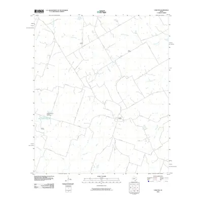
2010 Map of Carlton
USGS Topo · Published 2010About this map
Carlton stands as the central hub of this Hamilton County landscape, situated at the junction of several farm-to-market roads and local routes. The surrounding terrain is defined by a dense network of seasonal and perennial waterways, including the winding Gilmore Creek, Wolf Prong Creek, and Rocky Creek. These drainage patterns reflect the agricultural character of the region, where land management is evidenced by the Soil Conservation Service Site 24 Reservoir and its associated Soil Conservation Service Site 24 Dam to the west. Local history is anchored by several burial grounds dispersed throughout the countryside, such as Turribow Cemetery to the north, Altman Cemetery in the northeast, and Midway Cemetery near the western boundary. The map illustrates a rural Texas environment where transportation relies on a grid of county roads, like Co RD 128 and Co RD 272, connecting isolated farmsteads to the township.
Find a feature on this map
45 named features on this map. Tap any name to fly to it.
Don’t see what you’re looking for? This feature index may not catch every label — zoom into the map to look around manually.
Map Details
Editions of this 2010 Carlton Map
This is the sole edition of this map. No revisions or reprints were ever made.
Other maps of this area

1888 · Hamilton
USGS Topo · 1:125,000

1890 · Stephenville
USGS Topo · 1:125,000

1894 · Hamilton
USGS Topo · 1:125,000

1920 · Stephenville
USGS Topo · 1:125,000

1954 · Brownwood
USGS Topo · 1:250,000

1954 · Abilene
USGS Topo · 1:250,000

1956 · Gustine
USGS Topo · 1:62,500

1956 · Gentrys Mill
USGS Topo · 1:24,000

1956 · Hico
USGS Topo · 1:62,500
1956 · Eidson Lake
USGS Topo · 1:24,000