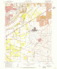
1954 Map of Carmichael
USGS Topo · Published 1955About this map
Carmichael and the surrounding Sacramento suburbs appear in a mid-century phase of rapid expansion, where residential subdivisions begin to crowd the historic ranching and agricultural lands. North of the American River, neighborhoods are organized around newly established local campuses like Mission Ave School and Orville Wright School. This growth contrasts sharply with the industrial landscape to the east, where extensive Dredge Tailings trace the legacy of resource extraction along the Southern Pacific rail line.
Find a feature on this map
51 named features on this map. Tap any name to fly to it.
Don’t see what you’re looking for? This feature index may not catch every label — zoom into the map to look around manually.
Map Details
Editions of this 1954 Carmichael Map
3 editions found
Other maps of this area

1891 · Sacramento
USGS Topo · 1:125,000

1892 · Sacramento
USGS Topo · 1:125,000

1893 · Sacramento
USGS Topo · 1:125,000

1894 · Lodi
USGS Topo · 1:125,000

1902 · Fairoaks
USGS Topo · 1:62,500

1908 · Buffalo Creek
USGS Topo · 1:31,680

1909 · Elk Grove
USGS Topo · 1:31,680

1909 · Cosumnes
USGS Topo · 1:31,680

1909 · Florin
USGS Topo · 1:31,680

1911 · Brighton
USGS Topo · 1:31,680