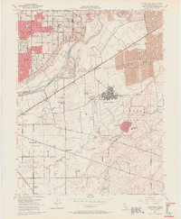
1954 Map of Carmichael
USGS Topo · Published 1964About this map
The Mather Air Force Base complex dominates the central landscape of this mid-century survey, surrounded by the evolving residential and agricultural outskirts of Sacramento. To the north, the growing community of Carmichael is defined by a dense network of suburban streets like Marconi Ave and El Camino Ave, while the eastern portion of the map reveals the massive Dredge Tailings along the American River, a stark industrial legacy of gold mining operations. The southern reach of the sheet remains largely rural, dotted with individual landmarks such as the Bellevue Cemetery, Walsh Station, and Friendship Church. Transport is anchored by the Southern Pacific and Central California Traction lines, which cut through a landscape of seasonal creeks and sloughs including Morrison Creek and Chicken Ranch Slough.
Find a feature on this map
51 named features on this map. Tap any name to fly to it.
Don’t see what you’re looking for? This feature index may not catch every label — zoom into the map to look around manually.
Map Details
Editions of this 1954 Carmichael Map
3 editions found
Other maps of this area

1891 · Sacramento
USGS Topo · 1:125,000

1892 · Sacramento
USGS Topo · 1:125,000

1893 · Sacramento
USGS Topo · 1:125,000

1894 · Lodi
USGS Topo · 1:125,000

1902 · Fairoaks
USGS Topo · 1:62,500

1908 · Buffalo Creek
USGS Topo · 1:31,680

1909 · Elk Grove
USGS Topo · 1:31,680

1909 · Cosumnes
USGS Topo · 1:31,680

1909 · Florin
USGS Topo · 1:31,680

1911 · Brighton
USGS Topo · 1:31,680