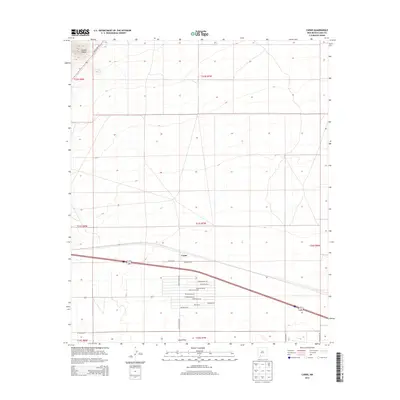
2013 Map of Carne
USGS Topo · Published 2013About this map
Carne sits at a crossroads in the Chihuahuan Desert landscape of Luna County, where the topography shifts from the rising slopes of the Cookes Range in the northwest to the flat basins of the southern desert. The settlement pattern here is defined by a distinct grid of residential and agricultural roads, particularly around the community of Lewis Flats. This area features an unusual concentration of Spanish-named thoroughfares, including Huerfeno Rd Ne, Poco Loco Rd Ne, and Pojoaque Rd Ne, suggesting a more modern planned development or rural subdivision adjacent to more established corridors like Hatch Hwy Ne. The landscape is largely defined by this intersection of traditional highway transit and concentrated rural residential blocks under the wide New Mexico sky.
Find a feature on this map
28 named features on this map. Tap any name to fly to it.
Don’t see what you’re looking for? This feature index may not catch every label — zoom into the map to look around manually.
Map Details
Editions of this 2013 Carne Map
This is the sole edition of this map. No revisions or reprints were ever made.
Other maps of this area

1899 · Deming
USGS Topo · 1:125,000

1915 · Deming
USGS Topo · 1:125,000

1955 · Las Cruces
USGS Topo · 1:250,000

1958 · Las Cruces
USGS Topo · 1:250,000

1964 · Florida
USGS Topo · 1:24,000

1964 · Massacre Peak
USGS Topo · 1:24,000

1964 · Florida Gap
USGS Topo · 1:24,000

1965 · Deming East
USGS Topo · 1:24,000

1965 · Carne
USGS Topo · 1:24,000
1965 · Capitol Dome
USGS Topo · 1:24,000