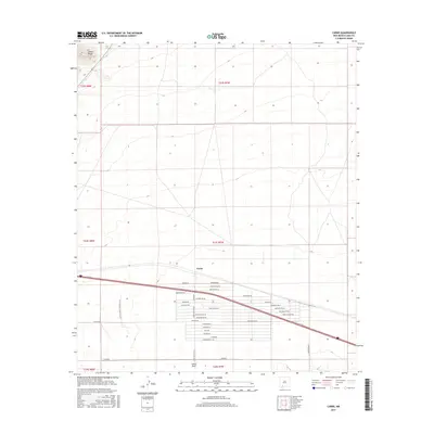
2017 Map of Carne
USGS Topo · Published 2017About this map
The southern foothills of the Cookes Range descend into the high desert plains of Luna County, where the settlement of Carne sits along a primary east-west transportation corridor. The landscape is defined by a dense grid of residential and ranch roads north of the interstate, including Geronimo Rd, Eldorado Rd Ne, and the playfully named Poco Loco Rd Ne. These roads imply a transition from open range to subdivided land use near the southern edge of the sheet. To the south, the community of Lewis Flats and the Amapoca terrain feature sit near the intersection of several county roads. A distinct modern landmark, the FAA Air Traffic Control Lock, stands out as a specialized infrastructure point within this desert environment, supporting regional aviation far beyond the residential clusters of Huerfeno Rd and Mundo Rd.
Find a feature on this map
37 named features on this map. Tap any name to fly to it.
Don’t see what you’re looking for? This feature index may not catch every label — zoom into the map to look around manually.
Map Details
Editions of this 2017 Carne Map
This is the sole edition of this map. No revisions or reprints were ever made.
Other maps of this area

1899 · Deming
USGS Topo · 1:125,000

1915 · Deming
USGS Topo · 1:125,000

1955 · Las Cruces
USGS Topo · 1:250,000

1958 · Las Cruces
USGS Topo · 1:250,000

1964 · Florida
USGS Topo · 1:24,000

1964 · Massacre Peak
USGS Topo · 1:24,000

1964 · Florida Gap
USGS Topo · 1:24,000

1965 · Deming East
USGS Topo · 1:24,000

1965 · Carne
USGS Topo · 1:24,000
1965 · Capitol Dome
USGS Topo · 1:24,000