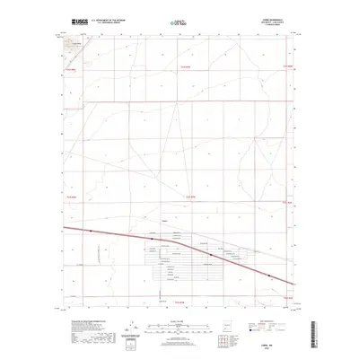
2020 Map of Carne
USGS Topo · Published 2020About this map
Carne and Lewis Flats sit at the center of a grid-defined landscape in Luna County, characterized by a transition from the elevations of the Cookes Range in the northwest to the low, developed tracts south of the interstate. The layout reveals a contemporary expansion of rural residential development, with numerous named corridors like Geronimo Rd, Eldorado Rd Ne, and the curiously named Poco Loco Rd Ne creating a dense web of access in the southern sections. An unusual technical landmark, the FAA Air Traffic Control Lock, stands near the western edge of this corridor, reflecting the area's role in modern transportation infrastructure. The map illustrates how legal boundaries like t23s r7w dictate the organization of land in this part of the Chihuahuan Desert, where traditional ranching roots meet modern logistical needs.
Find a feature on this map
33 named features on this map. Tap any name to fly to it.
Don’t see what you’re looking for? This feature index may not catch every label — zoom into the map to look around manually.
Map Details
Editions of this 2020 Carne Map
This is the sole edition of this map. No revisions or reprints were ever made.
Other maps of this area

1899 · Deming
USGS Topo · 1:125,000

1915 · Deming
USGS Topo · 1:125,000

1955 · Las Cruces
USGS Topo · 1:250,000

1958 · Las Cruces
USGS Topo · 1:250,000

1964 · Florida
USGS Topo · 1:24,000

1964 · Massacre Peak
USGS Topo · 1:24,000

1964 · Florida Gap
USGS Topo · 1:24,000

1965 · Deming East
USGS Topo · 1:24,000

1965 · Carne
USGS Topo · 1:24,000
1965 · Capitol Dome
USGS Topo · 1:24,000