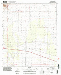
1996 Map of Carne
USGS Topo · Published 2003About this map
Lewis Flats and the surrounding high desert of Luna County reveal a landscape defined by water management and transit infrastructure at the close of the twentieth century. The small settlement of Carne sits alongside a primary transportation corridor, supported by a network of isolated water sources like Hannigan Well and the Peach Orchard Windmill. The terrain transitions from the alluvial fans of the south toward the rising slopes of the Cookes Range in the northwest. Local industry and utility are visible in the presence of a Sandpit and a Radio Facility, while the distribution of numerous named windmills, including Wolf Windmill and Eagle Windmill, underscores the historical reliance on groundwater for ranching and settlement in this arid New Mexico region. The map reflects a 1990s perspective built upon 1960s topographic data, documenting the enduring footprint of these rural features.
Find a feature on this map
13 named features on this map. Tap any name to fly to it.
Don’t see what you’re looking for? This feature index may not catch every label — zoom into the map to look around manually.
Map Details
Editions of this 1996 Carne Map
This is the sole edition of this map. No revisions or reprints were ever made.
Other maps of this area

1899 · Deming
USGS Topo · 1:125,000

1915 · Deming
USGS Topo · 1:125,000

1955 · Las Cruces
USGS Topo · 1:250,000

1958 · Las Cruces
USGS Topo · 1:250,000

1964 · Florida
USGS Topo · 1:24,000

1964 · Massacre Peak
USGS Topo · 1:24,000

1964 · Florida Gap
USGS Topo · 1:24,000

1965 · Deming East
USGS Topo · 1:24,000

1965 · Carne
USGS Topo · 1:24,000
1965 · Capitol Dome
USGS Topo · 1:24,000