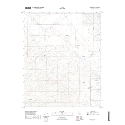
2018 Map of Carneros Rocks
USGS Topo · Published 2018About this map
The Temblor Range dominates the western landscape of this Kern County region, where the high ridges drop away toward the western edge of the San Joaquin Valley. This transition is marked by a series of significant geological and hydrological features, including the eponymous Carneros Rocks and the winding Carneros Canyon. The terrain is deeply incised by seasonal watercourses such as Chico Martinez Cr, Santos Cr, and Zemorra Cr, which drain the eastern slopes toward the valley floor. Evidence of the region’s industrial and agricultural activity appears in the network of utility and access roads, such as Wagon Wheel Rd and Waterflood Rd, serving the Bacon Hills and Gould Hill areas. The map provides a detailed view of the rugged topography between the Temblor Valley and the San Joaquin basin during the early twenty-first century.
Find a feature on this map
28 named features on this map. Tap any name to fly to it.
Don’t see what you’re looking for? This feature index may not catch every label — zoom into the map to look around manually.
Map Details
Editions of this 2018 Carneros Rocks Map
This is the sole edition of this map. No revisions or reprints were ever made.
Other maps of this area

1912 · McKittrick
USGS Topo · 1:125,000

1914 · Lost Hills
USGS Topo · 1:125,000

1932 · West of Goose Lake
USGS Topo · 1:31,680

1934 · West of Goose Lake
USGS Topo · 1:31,680
1942 · Hart Station
USGS Topo · 1:62,500

1943 · Simmler
USGS Topo · 1:62,500
1943 · Belridge
USGS Topo · 1:31,680
1943 · Shale Point
USGS Topo · 1:31,680
1943 · Blackwell
USGS Topo · 1:31,680

1948 · Bakersfield
USGS Topo · 1:250,000