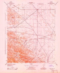
1943 Map of Shale Point
USGS Topo · Published 1943About this map
The Temblor Range defines the western edge of this 1943 survey, dropping sharply into the wide expanse of the Antelope Valley. The landscape is dominated by large-scale ranching and early petroleum exploration, evidenced by the presence of C Twisselmann Ranch and the USC & GS Shale Point Standard Oil Co marker. These features suggest an era where the rugged terrain of western Kern County was being systematically surveyed for resource extraction while maintaining established pastoral holdings. Ephemeral drainage systems like Bitterwater Creek and Devilwater Creek cut through the foothills, illustrating the arid character of the Antelope Plain before modern water management transformed the region. The map provides a precise record of these family-named landmarks and surveying stations during the mobilization of the early 1940s.
Find a feature on this map
11 named features on this map. Tap any name to fly to it.
Don’t see what you’re looking for? This feature index may not catch every label — zoom into the map to look around manually.
Map Details
Editions of this 1943 Shale Point Map
This is the sole edition of this map. No revisions or reprints were ever made.
Other maps of this area

1912 · McKittrick
USGS Topo · 1:125,000

1914 · Lost Hills
USGS Topo · 1:125,000

1914 · Cholame
USGS Topo · 1:125,000

1915 · Cholame
USGS Topo · 1:125,000

1917 · Cholame
USGS Topo · 1:125,000

1932 · Antelope Plain
USGS Topo · 1:31,680

1932 · La Panza
USGS Topo · 1:48,000

1935 · La Panza
USGS Topo · 1:62,500
1936 · Antelope Plain
USGS Topo · 1:31,680

1936 · La Panza
USGS Topo · 1:62,500