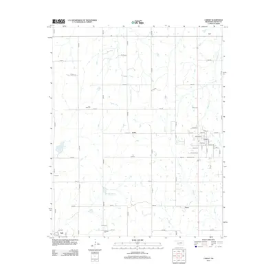
2012 Map of Carney
USGS Topo · Published 2012About this map
Carney serves as the primary hub in this section of Lincoln County, where a grid of rural roads connects the surrounding agricultural landscape and smaller settlements. The town's street plan is clearly delineated, featuring named thoroughfares like Santa Fe Ave and Frisco St that hint at its rail-oriented origins. Beyond the town limits, the landscape is defined by the drainages of Bellcow Cr and Dugout Cr, as well as several water management projects such as Bear Fall Coon Cr Site 3r Reservoir. Evidence of the region's diverse history is scattered throughout the countryside, marked by small rural nodes like Dudley and Emsey, along with several community burial grounds including Bethlehem Cem and Great Hope Cem. The presence of Oil Field Rd reflects the long-standing influence of the petroleum industry on the local economy and land use patterns.
Find a feature on this map
54 named features on this map. Tap any name to fly to it.
Don’t see what you’re looking for? This feature index may not catch every label — zoom into the map to look around manually.
Map Details
Editions of this 2012 Carney Map
This is the sole edition of this map. No revisions or reprints were ever made.
Other maps of this area

1905 · Chandler
USGS Topo · 1:62,500

1907 · Chandler
USGS Topo · 1:62,500

1908 · Agra
USGS Topo · 1:62,500

1909 · Luther
USGS Topo · 1:62,500

1909 · Perkins
USGS Topo · 1:62,500

1954 · Oklahoma City
USGS Topo · 1:250,000

1957 · Oklahoma City
USGS Topo · 1:250,000

1963 · Oklahoma City
USGS Topo · 1:250,000
1966 · Wellston
USGS Topo · 1:24,000
1966 · Luther
USGS Topo · 1:24,000